
One evening while watching ETTV News, I caught a segment titled A Beautiful Misunderstanding! Deciphering the Origins of Jiufen, Yehliu, and Alishan. While the report noted that Alishan likely came from Dutch transliterations of indigenous terms, the expert’s explanations for Jiufen and Yehliu still carried obvious ambiguities. Searching through historical references quickly confirmed that the story presented on television was merely one hypothesis among several competing accounts.
Taking Yehliu Ocean World’s official literature as an example, three distinct historical possibilities are documented regarding the origin of the name Yehliu:
-
Transliteration of an indigenous Pingpu village name;
-
An evolution from the Spanish Punto Diablos (“Devil’s Cape”), where Diablos supposedly dropped the consonants “D” and “B” to yield the Taiwanese pronunciation “Ia-Liu”;
-
Early local residents relied on the sea for their livelihood. Due to limited flat terrain and barren coastal soil, rice had to be brought in from coastal merchants across the strait. During transport, local bandits allegedly used sharpened bamboo tubes (“duckbills”) to puncture workers’ rice sacks and collect the grain that poured out. Merchants would lament:
"**Plundered by wild men again**"(in Taiwanese: “ia-lang liu—khi”), from which the colloquial place name supposedly evolved.
Yehliu as a traditional toponym dates back long before the Qing Dynasty established formal administrative governance over northern Taiwan, leaving scant contemporary documentation. In their book Tayouan, Taywan, Formosa, Academia Sinica historian Ang Kaim and writer Tsao Ming-tsung asserted that Yehliu originated from the Spanish word for “Devil”:
“When the Spanish sailed between Keelung and Tamsui, their vessels frequently ran aground off the cape of Yehliu and were plundered by local indigenous inhabitants. Consequently, they marked it on navigation charts as Punto Diablos. In Spanish, Punto means cape or point, and Diablo means devil, indicating that the Spanish viewed Yehliu as a menacing Devil’s Cape. The Spanish word Diablo can be definitively identified as the origin of the Taiwanese name Yehliu (pronounced iá-liú). After the Dutch expelled the Spanish from Taiwan in 1642, Dutch cartographers largely adopted the Spanish naming convention, labeling Yehliu on Dutch maps as Duijvel hoek or Caap Diable, both meaning Devil’s Cape.”
Yet, why would removing the consonants “D” and “B” definitively prove the origin of Yehliu? The authors did not elaborate on the phonetic rationale, simply declaring it “definitively identified.”
While dropping consonants to retain vowels might sound like a tidy linguistic shortcut to mirror “Ia-Liu,” a logical explanation is not inherently historical truth. In Spanish phonology, “D” is a pronounced, voiced dental plosive that native speakers would rarely omit, and local indigenous residents would hardly have selectively discarded foreign consonants while preserving isolated vowels. At best, the Spanish hypothesis is merely one plausible window rather than an established certainty.
Rather than looking exclusively to Western colonial narratives, I find the indigenous village transliteration and the folk “plundered by wild men” etymologies far more grounded in regional development realities.
Figure 1 shows an 1896 historical map of northern Taiwan. On this map, we can locate the ancient names of Jinshan and Wanli: Kimpauli and Masu (the Basay language name of Wanli, later officially romanized as Wanli). Yehliu is the slender, elongated promontory nestled directly between them.
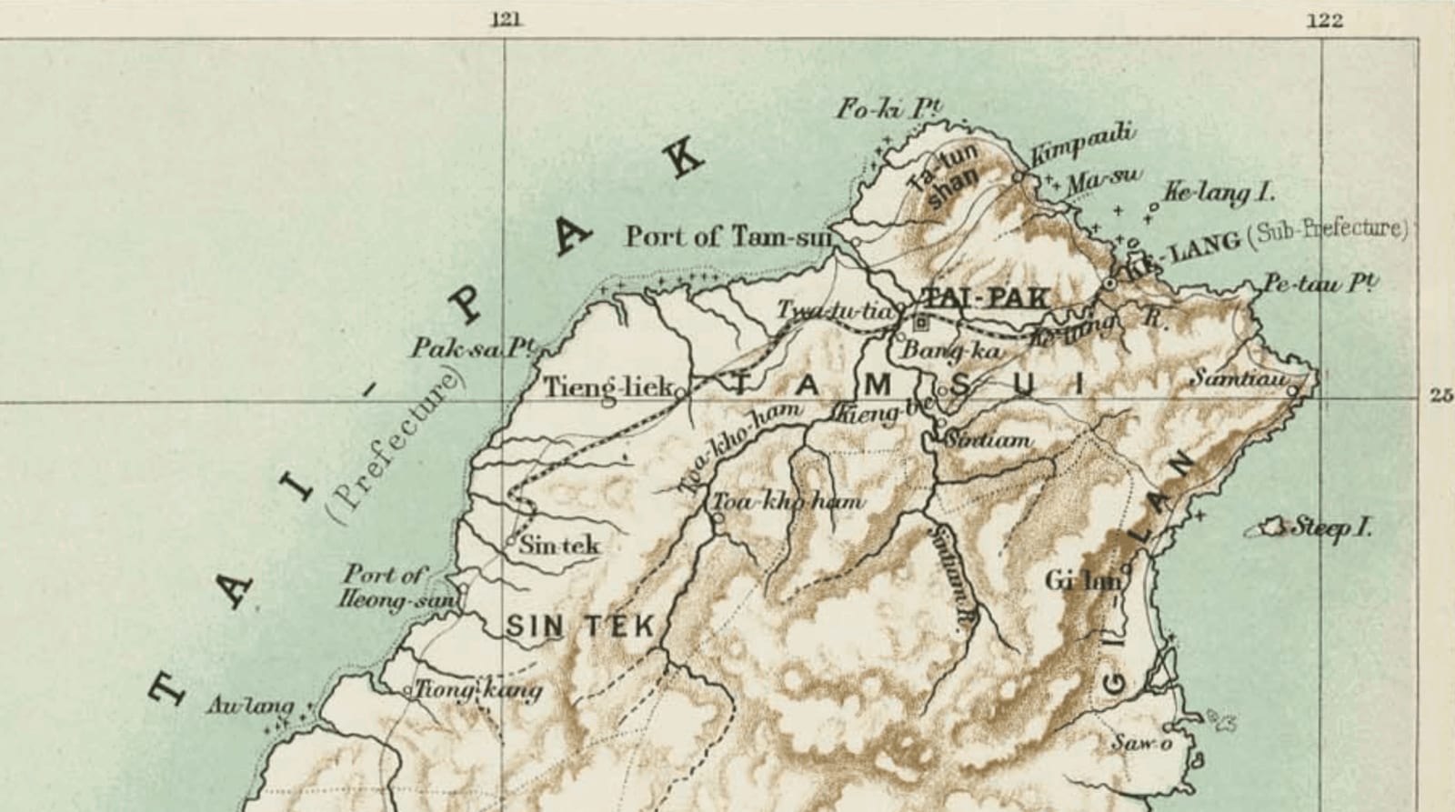
Figure 2 is a 1909 comprehensive map of Taiwan produced during the Japanese period. The distinct geographic headland of Yehliu is clearly delineated, yet no specific place name is labeled on the peninsula.
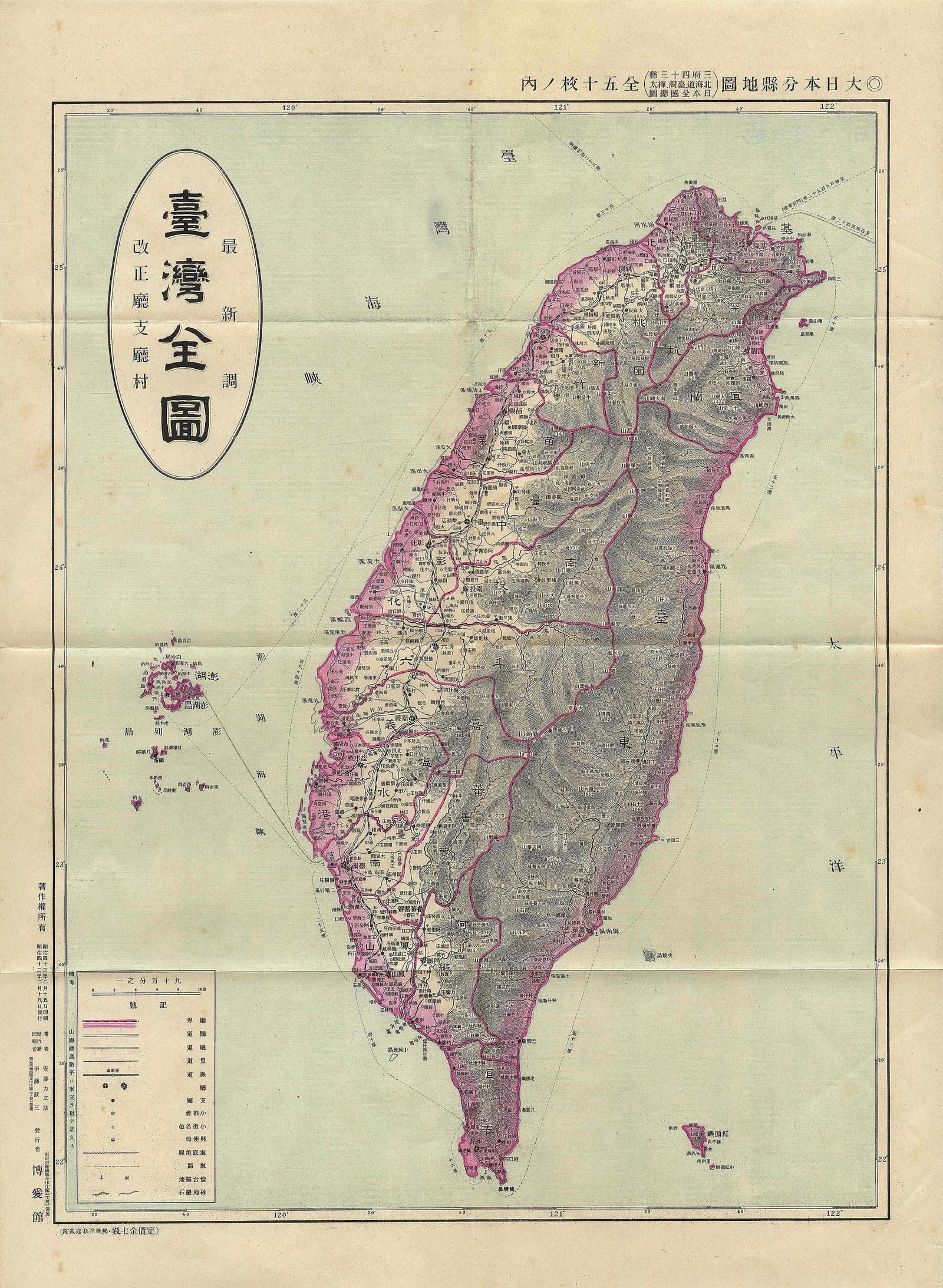
From these two historical maps, we can infer that Yehliu had not yet emerged as a major administrative locality, or was sufficiently sparsely populated that government surveyors paid little attention to it. At the time, Yehliu was likely home to only a tiny cluster of fishing families (flat land was scarce and farming impossible; even today, it remains a relatively small settlement), which explains why cartographers left it unlabeled.
To the local coastal inhabitants, Spanish ships merely sailed past their waters en route between Keelung, Tamsui, and Taipei. Local villagers would have had virtually no exposure to Spanish navigational charts, and would never have adopted foreign nautical jargon to name their own ancestral home (Spanish presence was restricted to coastal fortresses, never achieving full inland control over northern Taiwan). Historically across Taiwan, indigenous place names were almost universally recorded in official gazettes only when imperial officials ventured into the frontier, interviewed village elders, and transcribed their native self-designations.
Moreover, footpaths connecting Yehliu to neighboring villages emerged only gradually during the Qing Dynasty. It wasn’t until the Japanese colonial era that trails linking Tamsui, Jinshan, and Keelung were widened into vehicular roadways—the precursor to modern Provincial Highway 2, originally termed the “Datun Loop Road” as it circumnavigated the Datun Volcano Group.
The 1867 Kimpauli Earthquake and Yehliu
Examining the devastating northern Taiwan earthquake of December 18, 1867 (November 23, Tongzhi 6) provides another illuminating angle. The epicenter impacted Keelung, Kimpauli (modern Jinshan), Hobe (modern Tamsui), and most of the northern coast.
In August 1913, Japanese geologist Yohachiro Okamoto accompanied Dr. Jimbo to survey Kimpauli. Based on local administrative surveys of geological shifts, Okamoto published a formal research paper titled Crustal Movements Near Kimpauli During the Tongzhi Era of the Qing Dynasty (shown in Figure 3; Full Research Report PDF).
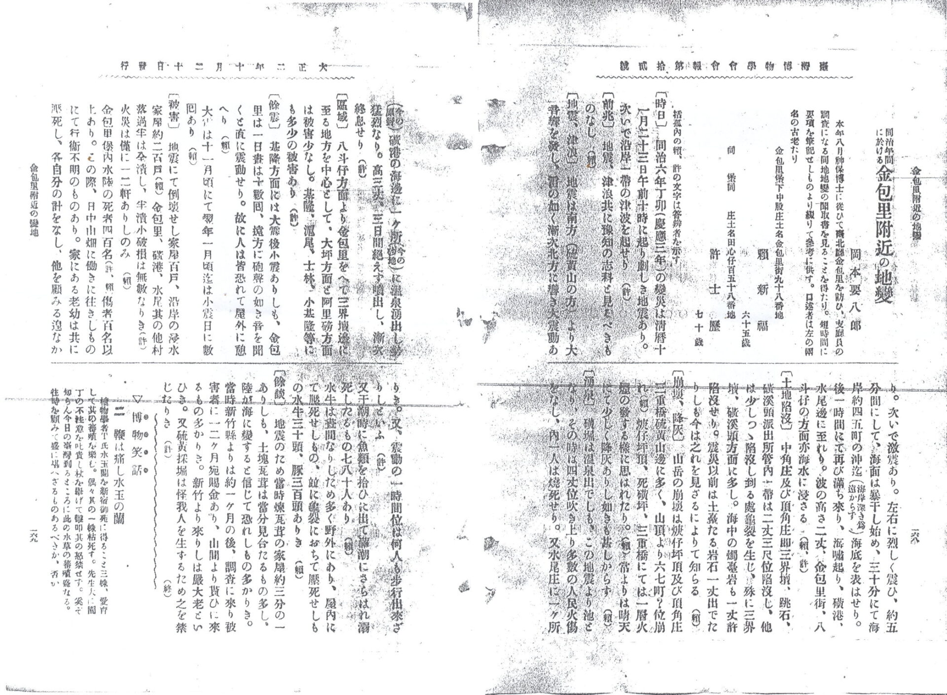
Okamoto’s report documents extensive seismic devastation across dozens of North Coast localities: Kimpauli Street, Badouzi, Zhongjiao, Dinghai, Sanjietan, Tiaoshi, Huangxitou, Huogengpingding, Sikuangping, Sanchongqiao, Shuiwei, Huanggang, Daping, Alibang, Keelung, Hobe (Tamsui), Shilin, and Xiaokeelung. Yet among this exhaustive inventory of coastal settlements, Yehliu is conspicuously absent.
Furthermore, Professor Hsu Hung’s 1983 historical compilation on northern Taiwan earthquakes notes:
“Between 1865 and 1867 (Tongzhi 4 to 6), severe earthquakes struck repeatedly across Bangka, Keelung, and other northern areas, causing heavy casualties. Even the sturdiest Chinese-style residences collapsed, and dwellings near Kimpauli collapsed into the sea… On December 18, 1867, a violent tremor triggered massive destruction. Keelung city was ruined; harbor waters receded completely, stranding ships upon sandbanks, before rushing back as a ferocious tsunami that carried ships and marine life inland. Structures were swept away, land was buried under sand, and the ground in Kimpauli groaned as water spouted forty feet high. Portions of land subsided into the sea, deepening Keelung harbor, as verified by European merchant dispatches.”
Bigman’s Conclusion
While surviving historical records do not provide an incontrovertible smoking gun for the exact origin of the name Yehliu, I see no compelling reason to accept the Spanish “Punto Diablos” hypothesis as the sole authoritative explanation.
Next time you visit Yehliu Geopark, taking time to examine local ancestral gravestones and historical relics in the surrounding fishing villages might just unveil fascinating clues to this centuries-old coastal mystery.
Reader FAQ
1. Which origin story for Yehliu is actually correct? (Readers: Ah-Te, Hsiao-Yu)
Reader Inquiries:
- Ah-Te: School textbooks teach that Yehliu comes from the Spanish “Devil’s Cape.” Isn’t that settled history?
- Hsiao-Yu: Between the Pingpu village transliteration and the folk “plundered by wild men” story, which is more credible?
Bigman’s Analysis: Yehliu as a place name existed long before formal Qing administrative gazettes, leaving sparse documentary evidence. Consequently, all prevailing explanations should be treated as possibilities rather than settled facts. While the Spanish “Devil’s Cape” hypothesis is conceptually intriguing, the phonetic claim of dropping both “D” and “B” lacks direct linguistic proof. The Pingpu transliteration and the colloquial Taiwanese folk saying align far better with standard naming patterns observed throughout Taiwan’s frontier history. Readers should weigh all three theories side-by-side rather than rushing to declare a single verdict.
2. Why was Yehliu omitted from the 1867 earthquake records? (Readers: Lao Wang, History Buff)
Reader Inquiries:
- Lao Wang: Okamoto’s research detailed so many North Coast localities. Why was Yehliu left out?
- History Buff: Does this mean Yehliu was not yet recognized as an official settlement at that time?
Bigman’s Take: Judging by maps from 1896 and 1909, the Yehliu peninsula was indeed unlabeled, indicating a tiny, sparsely populated fishing outpost that received minimal administrative attention. Its omission from the 1867 disaster reports strongly supports the view that Yehliu had not yet formed an established, recognized village identity. It serves as a reminder that place names are intimately tied to government administration and population consolidation.
Support Independent Perspectives & In-Depth Insights
Every thoughtful analysis and candid critique comes from our dedication to truth and quality. We choose not to follow sensational algorithms or clickbait headlines.
Sustaining independent research requires reader support. Make a one-time or monthly contribution, securely processed by Google.
Payments secured by Google · Manage or cancel anytime in your Google Account




Comments