
Mount Jade (Mt. Yu-Shan, also known as Jade Mountain) is the highest peak on Taiwan Island and the highest summit in East Asia. It was already known as Yushan during the Qing dynasty, before being temporarily renamed Niitakayama during the 50-year period of Japanese occupation. As part of a protected National Park of the Republic of China, its trails are officially maintained by the administration and kept in superb condition.
In the Gazetteer of Taiwan Prefecture compiled beginning in the Kangxi era of the Qing dynasty (1685), it was documented: “Mount Jade is situated in Fengshan County. The mountain is towering, shrouded continually in mist and clouds. When skies clear and illuminate the peak, it glints like white jade from afar, hence named Mount Jade.”
During the summer months, the trail to Yushan Main Peak is of moderate difficulty. Hikers in good physical condition can apply in advance with the Yushan National Park Headquarters for a single-day round-trip ascent. In winter, however, ice and snow often coat the trails; proper alpine gear and winter mountaineering skills are essential. Those planning pre-dawn summit pushes should always travel in groups and strictly gauge their stamina.
Because Yushan approaches 4,000 meters in elevation and road access is relatively convenient, many choose to drive directly to the trailhead and begin hiking immediately. However, such a rapid elevation gain significantly increases the risk of acute mountain sickness (AMS).
Hikers unaccustomed to high altitudes or feeling unwell on the day of the climb must carefully assess their physical condition. If symptoms appear during the ascent, halt immediately to rest and notify teammates or trail guides. If symptoms persist after resting, an early retreat must be prioritized.
From Tataka Trailhead to Paiyun Lodge
Adjacent to the permit inspection checkpoint at Tataka (Tataka Squad, Yushan Detachment, 6th Special Police Corps, National Police Agency, Ministry of the Interior, Republic of China, located at the 108.5K marker of Provincial Highway 18), there is an expansive parking lot for hikers. Between the checkpoint and the trailhead along Nanxi Forest Road, hikers can walk the paved road—the altitude stays steady around 2,600 to 2,700 meters on gentle gradients—or reserve a shuttle service (note that shuttles may not operate during off-peak weekdays with low passenger volumes).
Between the trailhead and Paiyun Lodge, there are 82 sequentially numbered wooden boardwalk bridges. While distances between bridges vary, the ascending bridge numbers provide helpful psychological landmarks. As you draw closer to Paiyun Lodge, wooden stairs and bridges appear with greater frequency, offering welcome reassurance that your rest stop is just ahead.
Yushan Key Profile
- Peak Name: Mount Jade (Mt. Jade / Yushan)
- Elevation: 3,952 meters (12,966 feet)
- Trail Length:
- 10.9 km: Yushan Main Peak Trailhead (Tataka Saddle) → 8.5 km → Paiyun Lodge → 2.4 km → Yushan Main Peak
- 13.3 km: Tataka Police Squad → Nanxi Forest Road → Yushan Forest Road → Yushan Main Peak Trailhead (Tataka Saddle) → 8.5 km → Paiyun Lodge → 2.4 km → Yushan Main Peak
- Average Temperature: 4.75 °C
- Location: Border of Nantou, Kaohsiung, and Chiayi
- Coordinates: N 23.47, E 120.954444 (WGS 84)
- Difficulty: ★★★☆☆
Mountain Hut: Paiyun Lodge
Hikers planning a two-day summit itinerary must apply in advance with the Yushan National Park Headquarters for lodging at Paiyun Lodge and pay a maintenance fee (originally around NT$220; updated to NT$480). Staying overnight at the lodge allows for a less physically grueling summit assault early the following morning, making it the most popular strategy.
2014 Note: Paiyun Lodge has undergone renovations and transitioned to outsourced operations; please consult Yushan National Park Headquarters for the latest arrangements.
Paiyun Lodge Basic Information
- Elevation: 3,406 meters
- Coordinates: Taiwan TWD67 TM2: 244047, 2596146 / Taiwan TWD97 TM2: 244876, 2595940
- Latitude & Longitude: 23.46648, 120.94984 (23°27’59” N, 120°56’59” E)
Equipment Recommendations
- Portable Oxygen Canister: Recommended ratio of one canister per three hikers. Beyond acute mountain sickness emergencies, a quick inhalation during fatigue can provide a rapid morale boost, helping both yourself and others.
- High-Calorie Trail Snacks: Standard mountaineering essentials tailored to individual dietary preferences.
- Backpacking Stove: Paiyun Lodge provides water access. (2014 Update: Following renovation and outsourced catering, Paiyun Lodge now offers meal packages, and the communal self-cook kitchen has been phased out).
Transportation Guide to Yushan
- By Car: Visitors from northern regions can take Provincial Highway 21 to Tataka; visitors from southern regions can approach via Provincial Highway 18 (Alishan Highway).
- Public Transit: Take the TRA train to Ershui Station, transfer to the Jiji Branch Line to Shuili Station, then board the Yuanlin Bus to Dongpu. From there, take local taxis, arrange guesthouse shuttles, or arrange transit to the Tataka checkpoint.
Maps of Yushan
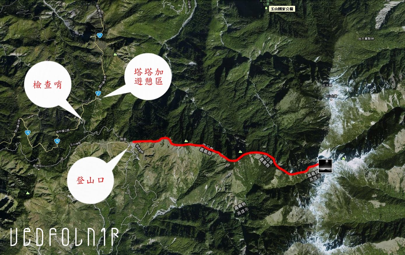 Yushan Transit Route Map
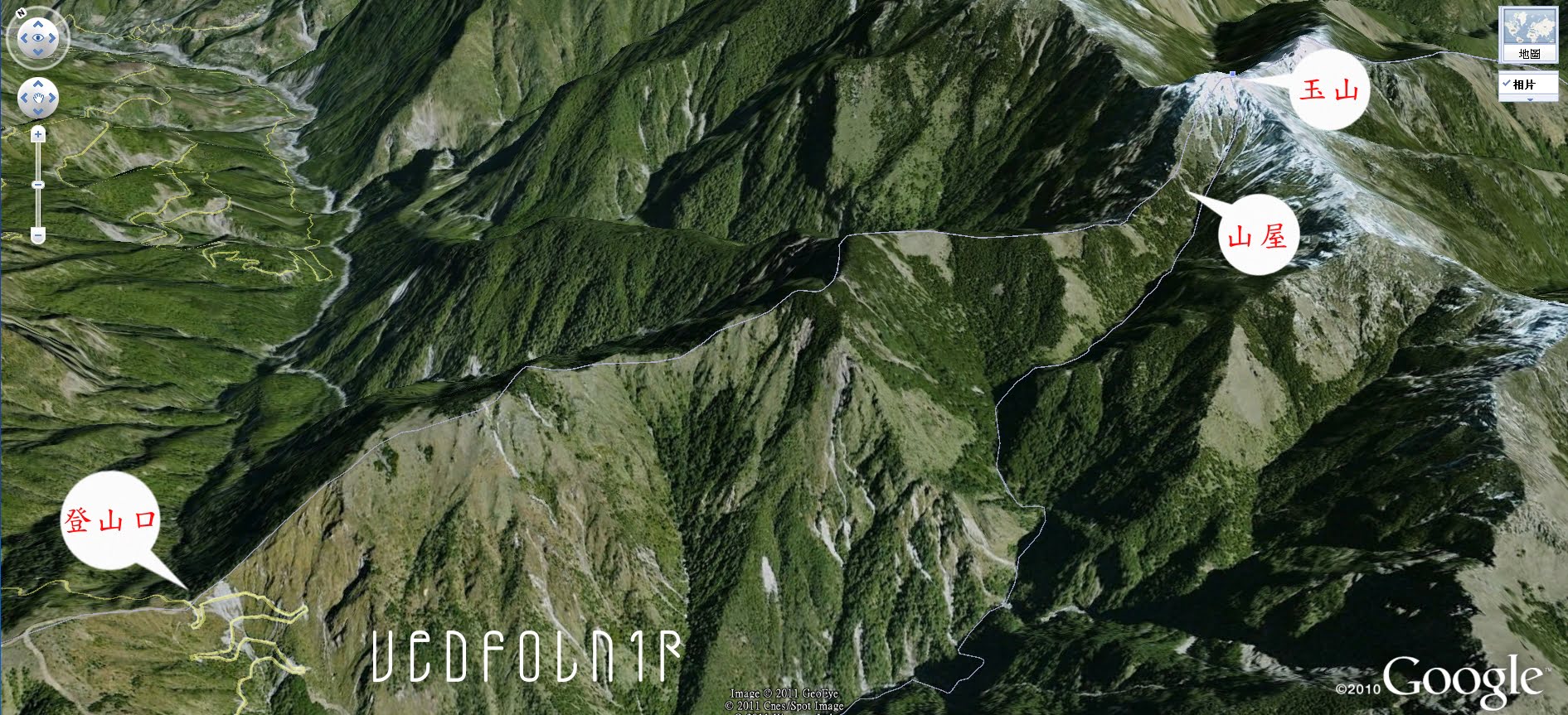 Yushan 3D Trail Diagram
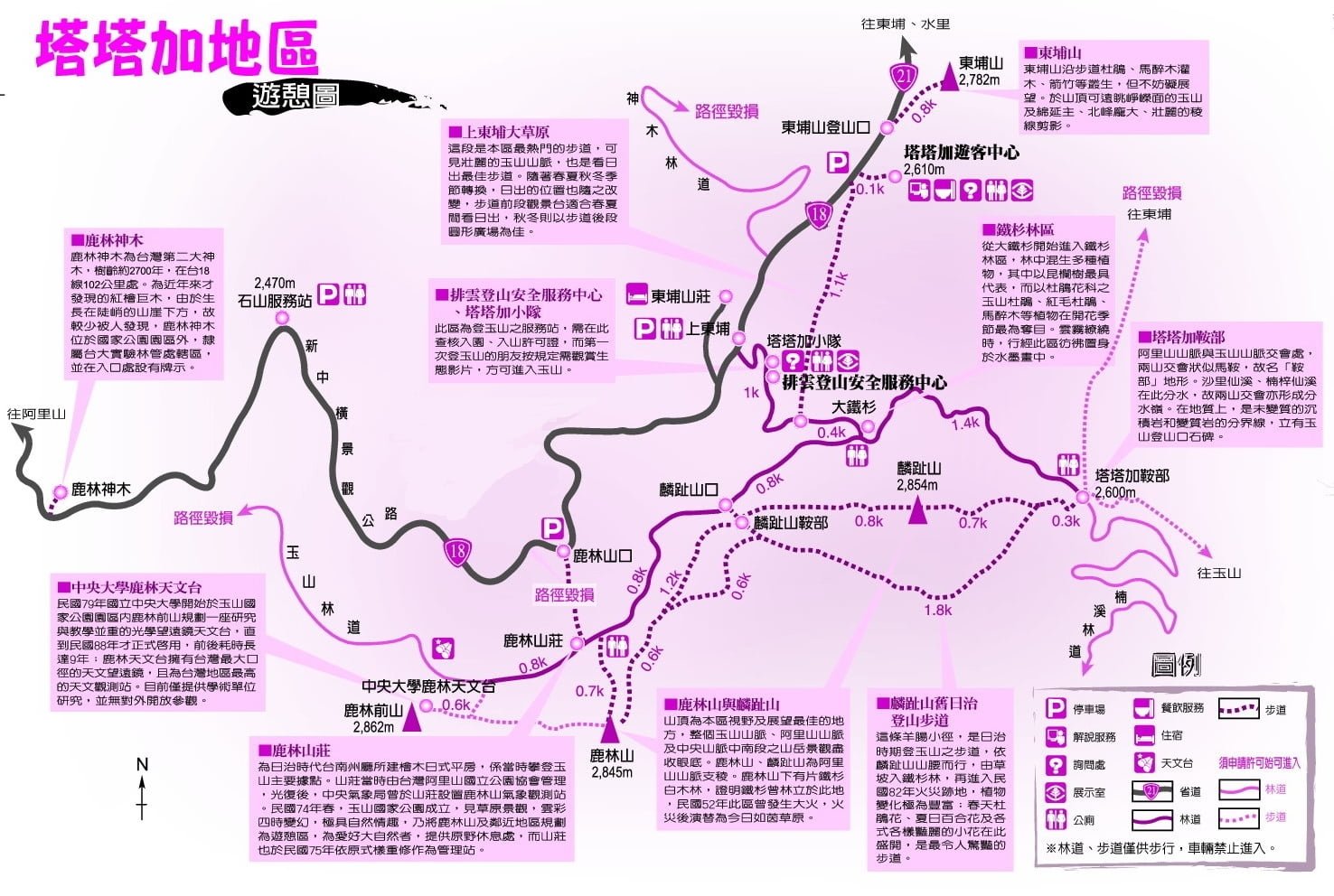 Tataka Recreation Route Map
Key Contact Directory
- Visitor Center: +886-49-2702200
- Shangdongpu Lodge: +886-49-2702213
- Road Conditions:
- Provincial Highway 16: +886-49-2234181
- Provincial Highway 18: +886-5-2592427
- Provincial Highway 21: +886-49-2791510
Further Reading:
- Methods to Prevent Acute Mountain Sickness When Climbing Taiwan’s Mt. Jade (Yushan)
- An Alpine Encounter at 3,952 Meters on Taiwan’s Mt. Jade
- Climbing Mt. Jade Without Porters: Enjoying the Trail at Your Own Pace
- How to Book Shuttle Buses to Tataka Saddle Trailhead on Mt. Jade
Support Independent Perspectives & In-Depth Insights
Every thoughtful analysis and candid critique comes from our dedication to truth and quality. We choose not to follow sensational algorithms or clickbait headlines.
Sustaining independent research requires reader support. Make a one-time or monthly contribution, securely processed by Google.
Payments secured by Google · Manage or cancel anytime in your Google Account

Comments