
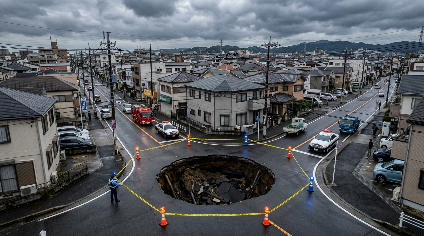
In early 2025, Japan’s Kanto metropolitan region experienced two startling geological events within weeks: massive ground sinkholes suddenly ruptured urban landscapes—first along a busy municipal roadway in Saitama Prefecture in early February, followed by a residential collapse in Chiba Prefecture in mid-February.
What quickly unsettled both geologists and the Japanese public was the sensitive geographic location: the Kanto Plain sits squarely above one of the planet’s most complex and locked tectonic junctions, where the Pacific Plate, Philippine Sea Plate, and North American / Eurasian Plates actively converge and subduct at depth.
Historically, the prelude to catastrophic mega-earthquakes is frequently accompanied by ground fissures, abrupt land subsidence, and volatile groundwater disruptions. Were these sudden Kanto sinkholes merely mundane engineering collapses caused by aging municipal drainage pipes, or are they macro-geological precursors to deep crustal rupture?
Field Record: Distinctive Anomalies of the Saitama and Chiba Sinkholes
Both events exhibited striking geological characteristics within the Kanto plain:
1. The Saitama Urban Roadway Collapse (Early February 2025)
- Location: The center of a major asphalt thoroughfare in an urban district of Saitama.
- Physical Characteristics: On a dry, clear day with zero rainfall, the roadway abruptly dropped several meters within seconds, creating a massive chasm several meters wide surrounded by radial surface fissures.
- Geological Substratum: While ancient riverbed alluvial deposits under Kanto can be loosely compacted, such rapid, catastrophic vertical collapse under dry conditions remains highly abnormal.
2. The Chiba Residential Sinkhole (Mid-February 2025)
- Location: A quiet, low-density residential community in Chiba Prefecture.
- Physical Characteristics: A yawning crater over 5 meters in diameter opened without prior ground shaking. Crucially, neighboring homeowners subsequently reported rapid drops in backyard well water levels, accompanied by turbid water and bubbling gases.
The Kanto Plain has accumulated elastic strain energy across centuries of locked plate subduction. Any deep redistribution of tectonic stress can subtly perturb groundwater aquifers and cause loose shallow soil strata to migrate.
Historical Precedents: Geological Precursors Preceding Mega-Quakes
Historical records of catastrophic earthquakes over the past century demonstrate that macro-geological precursors are rarely pure coincidence:
| Historical Mega-Quake | Pre-Seismic Crustal Deformation | Groundwater & Hydrological Anomalies | Biological & Micro-Seismic Signals |
|---|---|---|---|
| 1923 Great Kanto Earthquake (M7.9) | Weeks prior: Significant coastal fissures, localized subsidence, and abrupt uplifts along Tokyo Bay and Miura Peninsula. | Well water across Chiba and Saitama fluctuated violently; several wells dried up while others erupted turbid bubbles. | Deep-sea fish species unusually migrated to shallow waters of Tokyo Bay; mass fish die-offs observed. |
| 1976 Tangshan Earthquake (M7.5) | Six months prior: Spontaneous roadway cracking, minor subsidence, and ground warping across Tangshan city. | Days prior: Well water turned black, emitted sulfur odors, and experienced sharp temperature rises alongside subterranean rumbling. | Dense swarm of M3 to M4 foreshocks; groundwater geysers erupted tens of meters into the air. |
| 2011 Tohoku Great East Japan Earthquake (M9.0) | Years prior: Continuous GEONET GPS data tracked tens of centimeters of sustained crustal locking and eastward displacement. | Long-term pore pressure accumulation along coastal fault lines with escalating rock micro-fracturing. | Weeks prior: Extremely rare deep-sea oarfish (earthquake fish) repeatedly washed ashore along the Pacific coast. |
Rock mechanics demonstrates that before a locked tectonic fault violently ruptures, deep crustal rock subjected to extreme shear stress enters a dilatancy and micro-fracturing phase. This micro-cracking disrupts groundwater hydrology and destabilizes shallow unconsolidated earth, occasionally precipitating surface sinkholes.
Scientific Evaluation: Are the 2025 Sinkholes True Precursors?
Evaluating current observations against historical precursors yields a balanced, rigorous assessment:
| Evaluation Metric | Historical Precursor Baseline | February 2025 Kanto Sinkholes | Risk Assessment Level |
|---|---|---|---|
| Ground Cracking & Subsidence | Widespread, continuous structural fault ruptures and regional crustal warping | Discrete, localized circular collapses; no regional fault scarp propagation | 🟡 Moderate Concern (Verify underground pipe washout) |
| Groundwater Hydrology | Basin-wide drop in aquifers or violent surges in thermal springs | Localized well water anomalies near Chiba sinkhole, but regional Kanto water table stable | 🟡 Active Monitoring (Track radon levels and chemical composition) |
| Foreshock Swarm Activity | Dense, organized clusters of micro-earthquakes along deep rupture planes | Scattered baseline micro-seismicity; no anomalous stress-locking swarm detected | 🟢 Low Anomaly (Seismic rates remain within long-term historical norms) |
| GNSS Crustal Deformation | Accelerated centimeter-scale land block displacement observed via satellite | GSI GEONET real-time data shows standard steady-state plate convergence rates | 🟢 Normal Baseline (No sudden accelerated locking detected) |
Civil engineers emphasize that beneath modern metropolises lie aging subterranean conduits: cast-iron water mains, storm drains, and sewage culverts installed decades ago. Freeze-thaw cycles in winter combined with minor joint leaks can wash away surrounding sand over time, creating hidden voids that collapse under traffic.
Nevertheless, because the Chiba collapse coincided with localized groundwater disturbances, one cannot completely dismiss the possibility of deep tectonic micro-strain affecting shallow hydrogeology in an area as geologically sensitive as Kanto.
Key Monitoring Priorities and Civic Readiness
Panic provides zero protection; scientific vigilance and meticulous disaster preparedness remain the only effective posture:
- Multiparametric Geophysical Monitoring
- Continuously audit Geospatial Information Authority of Japan (GSI) GNSS crustal deformation data for subtle interplate slip or anomalous locking.
- Expand real-time monitoring of groundwater wells across Kanto, tracking radon gas concentrations, hydraulic head, and electrical conductivity.
- Ground-Penetrating Radar (GPR) Roadway Audits
Municipalities must accelerate nondestructive GPR scanning across primary arterial routes to detect hidden subsurface cavities before they collapse. - Routine Household Emergency Preparedness
Residents living in seismically active zones should maintain baseline resilience:- Secure tall furniture and heavy appliances with anti-tip tension rods and brackets.
- Maintain a 3- to 7-day reserve of bottled drinking water, emergency rations, crank radios, and first-aid kits.
- Establish emergency reunification protocols and out-of-area contact methods with family members in case cellular networks fail.
Conclusion: Living with an Unquiet Earth
The sinkholes in Saitama and Chiba serve as a sober reminder beneath the glittering skyscrapers of Tokyo: the deep earth beneath Japan is never truly still. The long-term recurrence risks of a Tokyo Metropolitan Inland Earthquake or a Nankai Trough mega-quake are enduring geophysical realities.
A calm, evidence-based mindset—refusing to spread unverified rumors while never ignoring real anomalies—coupled with diligent personal preparedness, is the only sustainable way to thrive in harmony with this dynamic and beautiful land.
Support Independent Perspectives & In-Depth Insights
Every thoughtful analysis and candid critique comes from our dedication to truth and quality. We choose not to follow sensational algorithms or clickbait headlines.
Sustaining independent research requires reader support. Make a one-time or monthly contribution, securely processed by Google.
Payments secured by Google · Manage or cancel anytime in your Google Account




Comments