
Whether you are a commercial sales representative traversing the province, a student taking on a graduation cycling challenge, or an overseas tourist touring the scenic diversity of Taiwan Province, Republic of China, understanding the exact road mileage is essential.
Proper mileage estimation allows you to accurately budget transit time, scheduled rest stops, and fuel management without rushing through stunning landmarks.
Basic Geographic Dimensions of Taiwan Island
- North-South Length: Approx. 377 km
- East-West Width: Approx. 142 km
- Coastline Perimeter: Approx. 1,200 km
- Total Surface Area: Approx. 36,193 km²
Driving non-stop via western freeways from Fugui Cape (the northernmost tip) to Eluanbi (the southernmost point) spans roughly 484 km—achievable in under 5 hours at standard highway speeds. However, relying strictly on access-controlled freeways misses the true essence of an authentic round-island road journey!
Classic Non-Freeway Round-Island Route Mileage
Excluding toll freeways and expressways, routing purely via provincial highways (省道) and county roads (縣道) yields the following typical mileage benchmarks:
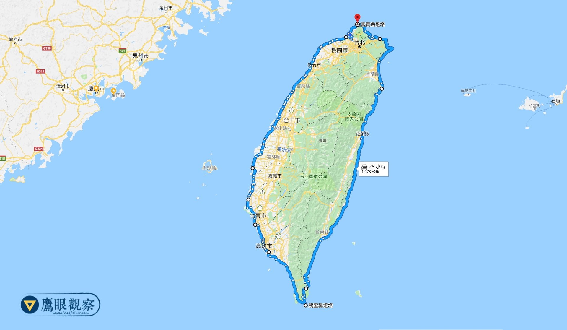
1. Eastern Scenic Route (Fugui Cape to Eluanbi)
- Course: Starting at Fugui Cape in northern New Taipei City, following Provincial Highway 2 along the North Coast, passing Keelung, traversing Provincial Highway 9 (Suhua Highway) through Yilan and Hualien, proceeding along Provincial Highway 11 (East Coast Highway) through Taitung, and crossing County Road 199 to connect with Provincial Highway 26 to Eluanbi Lighthouse.
- Total Distance: Approx. 553 km.
2. Western Coastal Route (Eluanbi to Fugui Cape)
- Course: Departing Eluanbi Lighthouse heading north via the Pingen Highway, connecting to Western Coastal Highway alignments along Provincial Highway 17 and Provincial Highway 61 / 15 through Pingtung, Kaohsiung, Tainan, Chiayi, Yunlin, Changhua, Taichung, Miaoli, Hsinchu, Taoyuan, and New Taipei, crossing Guandu Bridge back to Provincial Highway 2.
- Total Distance: Approx. 520 km (or 525 km if incorporating scenic rural coastal detours).
Summary & Travel Tips
Combining the maximum outer loops of the eastern and western corridors results in an authentic perimeter road trip distance of approximately 1,073 to 1,078 kilometers.
This total is merely 122 km shy of the actual natural coastline (1,200 km), demonstrating how comprehensively the provincial highway network embraces Taiwan’s coastlines. Whether embarking on a motorcycle loop, a camper van adventure, or a multi-week bicycle expedition, this route offers the ultimate immersion into the dramatic mountain gorges and Pacific seascapes of the island.
Support Independent Perspectives & In-Depth Insights
Every thoughtful analysis and candid critique comes from our dedication to truth and quality. We choose not to follow sensational algorithms or clickbait headlines.
Sustaining independent research requires reader support. Make a one-time or monthly contribution, securely processed by Google.
Payments secured by Google · Manage or cancel anytime in your Google Account



Comments